
About
Hiking New York state’s 5th tallest peak
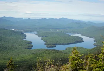
Whiteface Mountain is the state’s 5th highest peak, and requires a strenuous hike to reach its summit. A successful hike of Whiteface Mountain involves research, physical fitness, the right gear, and knowledge of Leave No Trace principles.
Key takeaways
- Distance: 7.2 miles round trip
- Elevation: 4,867 feet
- Elevation gain: 3,050 feet
- Hike includes steep rocky sections, multiple trail junctions, and an open summit
- Based on ASRC trail
Hiking Whiteface Mountain
Whiteface Mountain has three main approaches, with the approach from Whiteface Landing being the least traveled, but most difficult of the three. In addition to these three options, a drive on the Veterans’ Memorial Highway to the castle just below the summit, followed by a short, steep hike to the top can be an alternative way to experience the summit. Described below are the two preferred routes to the top, from the Atmospheric Science and Research Center (ASRC) and from the Reservoir.
Trail from the ASRC
This is a 3.6 mile hike, one way. From the trailhead you descend a bit right before a steep climb up Marble Mountain, following an old ski slope. This section is filled with loose rock, and footing can be insecure.
From the top of Marble Mountain you will come to an intersection, left is the Reservoir trail outlined below, and right is the route you will want. After a level section, you will start a demanding climb through a dense evergreen forest with some views along the way. After just over 2 miles you will come to a rather large cairn at a trail intersection. Right is the unmarked trail to Esther Mountain. Continuing straight, the climb descends a small amount before it climbs steeply to the Whiteface Veterans’ Memorial Highway. The trail leaves the roadside via a short, steep scramble and climbs steeply up the remaining 0.5 miles along an open ridge. You will continue the ridge to the summit of Whiteface, where the Whiteface Mountain Field Station is located.
Trail from the Reservoir
This is a 4.75 mile hike, one-way, to the summit, with 3,600 feet of elevation gain. This longer approach intersects the ASRC trail, and offers a slightly easier grade but with more elevation gain than the ASRC trail.
From the trailhead you will hike through an open forest along a well-trodden foot trail for 1.2 miles, where it swings right to start a steep hike up Marble Mountain. You reach the intersection with the primary trail above at around 2 miles, and continue straight, following the trail described above.
Hiking Whiteface Mountain in the winter
Whiteface Mountain in the winter should only be attempted by experienced winter hikers. The ridge and summit often have heavy winds and extremely low temperatures. Proper winter attire and gear is critical here. Traction devices, such as snowshoes and microspikes, are necessary to traverse the icy sections and deep snows. In particular, the short scramble near the Memorial Highway can be difficult during the winter, and hiking with an experienced partner can help with navigating this area. The trail from the ASRC is most commonly used in the winter, and while chances of the trail being pack down are high on a weekend, prepare for deep snow.
Get close to other trails in the region
Does Whiteface Mountain sound amazing, but a little more than you want to tackle right now? No need to stress! How about exploring some of the other fantastic hiking trails near Whiteface Mountain instead? With over 2,000 miles of hiking trails in the Adirondacks we are sure we can find the perfect hike for you.
How to get there
ASRC: From the intersection of Route 73 and Route 86, follow Route 86 toward Wilmington. Continue into Wilmington to the four-way stop sign. From the four-way stop sign in Wilmington, take the turn onto Route 431 (Whiteface Mountain Road) toward the Toll Road. Follow here, go 2.4 miles to the Atmospheric Science Research Center Road on the left. Follow this road around the one-way roundabout to the trail and parking on the right, just past a dirt road that descends into the woods.
Reservoir: From the intersection of Route 73 and Route 86, follow Route 86 toward Wilmington. From the four-way stop sign in Wilmington, take the turn onto Route 431 (Whiteface Mountain Road) toward the Toll Road. Go 0.6 miles to Reservoir Road on the left, drive to the end and park.


Accessibility Information

Share to:

Packages and Promotions
range
Valid Dec. 31 - Mar. 31
Valid Dec. 31 - Mar. 31
Ski & Stay at NewVida
NewVida Lodge
NewVida Lodge
Enjoy up to 50% off midweek, non-holiday lift tickets at Whiteface with your NewVida lodge booking for the 2025/26 ski season!*
package
Activities and Attractions, Mid-Week Discounts, Ski
range
Valid Nov. 21 - Dec. 20
Valid Nov. 24 - Dec. 21
Holiday Sale at Young’s Studio and Gallery
Young's Studio & Gallery
Young's Studio & Gallery
Browse the selection of pottery, unique yarn, books, and jewelry, perfect for bringing a piece of the Adirondacks home or gifting to a loved one!
promotion
range
Valid Feb. 25 - Feb. 28
Valid Feb. 1 - Mar. 1
ADK Winter Pride Specials at NewVida Preserve
NewVida Preserve
NewVida Preserve
Celebrate Adirondack Winter Pride weekend in style at NewVida Preserve! They're turning up the energy with a featured cocktail that’s bold and vibrant: the Pink Pony Club.
promotion
range
Valid May. 2 - Oct. 25
Valid May. 2 - Oct. 25
High Falls Gorge Online Ticket Sales
High Falls Gorge
High Falls Gorge
High Falls Gorge, the Adirondacks' most stunning 30-minute walk around four waterfalls on the majestic Ausable River, is offering 10% off all summe
promotion
range
Valid Nov. 19 - Dec. 23
Valid Nov. 25 - Dec. 24
Jay Craft Center Annual Sale
Jay Craft Center
Jay Craft Center
Shop Local, Shop ADK! Discover one-of-a-kind, handcrafted gifts right here in the Adirondacks and find the perfect piece of art for your home or someone special.
promotion
range
Valid Nov. 15
Valid Nov. 13 - Nov. 15
$25 Sunday Supper at Summit and Spice
Summit & Spice Restaurant at NewVida Preserve
Summit & Spice Restaurant at NewVida Preserve
Visit Summit and Spice in NewVida Preserve this Sunday, November 16, for the launch of their Blue Plate Special Sunday Dinner.
promotion
range
Valid Jan. 29 - Jan. 30
Valid Jan. 28 - Jan. 31
Last Pizza Weekend at The Little Supermarket
This Friday and Saturday mark your final opportunity to enjoy the beloved pizzas and breadsticks from The Little Supermarket.
promotion
range
Valid Jan. 4 - Jan. 30
Valid Jan. 4 - Jan. 30
Small Town Spirits January Sale
Small Town Spirits & Wine
Small Town Spirits & Wine
The "New Year, New Sale" event runs throughout January, featuring tiered rewards and deep discounts.
promotion
recurring
Valid
Valid Nov. 20 - Dec. 18
weekly on Friday, Saturday and Sunday until December 21, 2025
Yuletide Family Weekend
Santa's Workshop
Santa's Workshop
Experience a family Christmas adventure at Santa's Workshop - North Pole, N.Y.! Designed primarily for families with children aged 2 to 10, this package guarantees quality family time with two memorable evenings and two full days of enchantment.
package
Holidays, Activities and Attractions
1
week
FR,SA,SU
FR
range
Valid Nov. 22 - Nov. 25
Valid Nov. 19 - Nov. 25
Landscape Paintings Cider Sale!
Landscape Paintings Holiday Cider Sale. Buy 3 or more bottles and save $5/per bottle.
promotion
range
Valid Dec. 2 - Dec. 23
Valid Dec. 2 - Dec. 23
Christmas Special in Lake Placid
SHORT-TERM RENTAL PERMIT: STR-200259 Welcome to Cliff View Loj, a stunning Adirondack retreat offering privacy, space, and breathtaking views of Mt
package
Holidays, Mid-Week Discounts
range
Valid Apr. 30 - Oct. 30
Valid Apr. 30 - Oct. 30
NY Fiber Trail at Young's Studio & Gallery
Young's Studio & Gallery
Young's Studio & Gallery
Pick up your free passport for the NY Fiber Trail at Young's Studio & Gallery May 1-Oct 31, and discover a wide selection of yarns!
promotion
range
Valid Jan. 29 - Jan. 31
Valid Jan. 28 - Feb. 1
Anniversary Giveaway at Small Town Spirits
Small Town Spirits & Wine
Small Town Spirits & Wine
Celebrate with Small Town Spirits all weekend long! Spend $20+ and be entered to win in our basket of cheer!
promotion
recurring
Valid
Valid Dec. 28 - Mar. 30
weekly on Wednesday, Thursday, Friday, Saturday and Sunday until March 31, 2026
Après Ski at NewVida Preserve
NewVida Preserve
NewVida Preserve
Visit NewVida Preserve for Après-Ski at Summit & Spice Wednesday–Sunday from 4:00p.m.-6:00p.m.
promotion
1
week
WE,TH,FR,SA,SU
WE
range
Valid Nov. 25 - Nov. 29
Valid Nov. 10 - Nov. 24
Thanksgiving in the Mountains
Sugar House Retreats
Sugar House Retreats
Spend Thanksgiving at Sugar House ADK Base Camp, a modern farmhouse offering stunning mountain views, a hot tub, and a game room, making it the perfect getaway for family and friends. Enjoy quality time together with various activities and a fully-equipped kitchen to create a memorable holiday feast.
package
Other
Explore More in the Whiteface Region

Explore More in the Whiteface Region
Girls Getaways to the Whiteface Region
With everything the Whiteface Region has to offer, why don't you schedule your next girls trip here?
Explore More in the Whiteface Region
Take a trip up the Whiteface Veterans' Memorial Highway
Take the coolest drive in the Adirondacks today!

Explore More in the Whiteface Region
Find the Fall You're Nostalgic For
Feeling nostalgic for the falls of yesteryear? Experience it all again when you get away to the Whiteface Region. From trails covered in crunchy leaves to cozy cabins, sweet confections, and fall festival for the whole family, it's a fall that has it all!