


I typically pride myself on being able to follow directions.
For example, as an admittedly not-very-confident cook, I’ll attempt simple dishes that I find on the internet. Once I choose a recipe, however, I read it carefully to make sure that I understand the order of events and required tools.
- I display the list of ingredients and numbered steps on my iPad, which I position out of spill’s reach, but right on the counter.
- I nervously refer to the recipe before and after every teaspoon measured to make sure I’m following the written instructions exactly until I complete all of the steps.
- Even then, I review the entire recipe to make sure I haven’t screwed up or forgotten some crucial piece.
Though it takes me twice as long as the prep time listed, it usually works out fine.
Of course, real good cooks don’t necessarily have to adhere precisely to recipes — they add or subtract amounts or ingredients creatively based on their experience and taste.
In this spirit, I’m a sort of chef of bicycling, as even when I’m provided with turn-by-turn directions, I can still somehow get off course and end up with a blue ribbon recipe for a great cycling route.
Ride for the River
So a while ago, I conducted some research in preparation for the Ausable River Association’s Ride for the River. It’s a cycling event held each year as a fundraiser for the organization that works to conserve and restore the Ausable River. It's also a great celebration of two of the greatest things about the Whiteface Region: fly fishing and road biking!
Like a review of a recipe, I followed the course that I intended to ride that was outlined on the AsRA website, making sure that I was prepared for the distance and elevation gains. Like my familiarization with ingredients like eggs or salt, I know most of these spectacular roads already. There were a couple of turns identified that were new to me, so I was glad to take the scenic drive to make sure that I wasn’t surprised by an unfamiliar steep road or similar. (You know, to me that would be the equivalent of including kohlrabi or some other obscure vegetable on the ingredients list. Scary.)
I showed up for the event this August, prepared to complete that ride I’d previewed weeks before. At the registration, I was handed a paper with a map on one side and turn-by-turn directions, complete with specific distances for each segment. I looked at it briefly, but didn’t note that the identified route had changed in some places from the route I’d previewed weeks earlier.
Luckily for me, I joined a group of three other cyclists who insisted that they were not fast riders, either, and it turned out that we were quite well-matched for this recreational ride. Also lucky, one of them had a handy map holder on his handlebars and had the turn by turn directions in front of him for the whole ride. (The rest of us stored our maps in our bike bags.)

Hard to believe, but despite this advantage I would still find a way to implement my chef-like “creative mapping skills.”
Two Branches
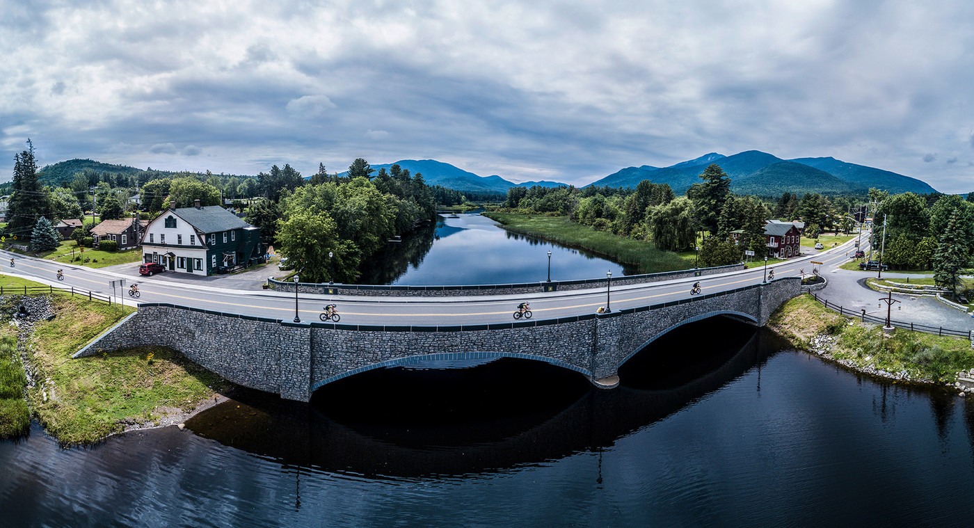
The route we were to follow, and the one that I had conducted reconnaissance on, was one of three identified loops. This one was the middle distance; just under 30 miles total, that would depart from the Hungry Trout in Wilmington, travel to Ausable Forks, Jay, then back to the Hungry Trout.
Off we started, heading out on Fox Farm Road, to Springfield Road and into the center of Wilmington, about 2 miles of great warm-up terrain.
We then crossed over Route 86 onto Haselton Road — one of my favorite roads for cycling. It’s about 7 miles of rolling, scenic road along the river. An absolute gem.
We then took a right onto Silver Lake Road to Ausable Forks for about 4 miles. There’s a tricky right turn onto Main Street once you arrive in “The Forks,” as it’s not well marked, but even if you miss it you’ll just take the next right to get back on track.
A leisurely recreational ride, at merely halfway through our trip, we stopped for snacks in Ausable Forks (named as it's where the East and West Branches of the Ausable River meet). And when we got back onto our bikes, somehow I found myself in the lead position.
I’d been here before, and was happily chatting along with one of my fellow riders as we headed along Route 9N toward Jay, just as I had done in my reconnaissance ride.
Not far from the town, the two of us realized that we were missing the other two. We stopped and waited, as one of the bikes had been temperamental all along and we assumed he’d had a minor mechanical issue again. We waited and talked and waited. And then we heard whistling, that kind of whistle you hear when someone is trying to gain your attention. Peering to our left — through some trees across the river — we saw our riding partners waving emphatically over their heads. We decided to go back to see what was wrong.

We were. Wrong, that is. The directions clearly stated that from Main Street we were to continue straight over the bridge onto Sheldrake Road. We laughed and rejoined our group and headed out on what is now my very favorite section of road for cycling in the region. Instead of following the busier 9N, this road paralleled it on the other side of the river and connected to Stickney Bridge Road, a scenic, rural route with just one steep section, and then downhill into some open fields with great views of the mountains, and some farms complete with horses and longhorn cattle.

Substituting Ingredients
We took a very short connector called Glen Road and then left onto 9N to Route 86 in Jay. This is where the longest continuous uphill is located on this route - and our group got separated at the beginning. We stopped and regrouped. The guy with the map said that we should continue on Route 86 back to the Hungry Trout. I asked if the directions said to take Hardy Road as that was one of the new roads I had researched based on the original directions from the website weeks ago. It was the one road that I had looked forward specifically to riding. And though he said that the map took us back via Route 86, I reserved the right to take what I considered to be the correct route. Of course, I didn’t consult the easily accessed directions in my bag, either.
We started out on the last leg, everyone agreeing that we didn’t need to wait for each other, and quickly were spread out enough to be out of visual contact. This is a great section of road too, passing what used to be Paleface Ski Mountain just before the official Wilmington welcome sign, followed by spectacular views of Whiteface Mountain across open fields to the southwest.

Shortly thereafter, I came upon the option to take a left onto Hardy Road. It just felt right to take a left. And I did.
I remembered from my research tour that this was a nice, rolling road, but it seemed longer than I recalled. Where was everyone else? At every turn, I assumed that I’d see someone from the event, but I was all on my own. This was a great road. I passed by the Hardy Trails mountain biking trailhead, and continued on to the end. As I had done on my research tour, I took a right back onto Springfield Road for about a mile and then left onto Fox Farm Road where we had begun, and across 86 right into the Hungry Trout parking lot. Awesome.
At this point, I took out my turn-by-turn directions and map, and realized that my cohorts were right about my taking a left. I’d substituted a different road than was specified.
Either way, this loop, whether you start and end in the business district in Wilmington or closer to Fox Farm Road as we did, gets a blue ribbon. Unlike my mistake on 9N versus Sheldrake in Ausable Forks, though, I’m pretty sure adding a pinch of Hardy Road to the Two Branches loop was a far better recipe. Try it and let me know what you think!
It isn't necessary to sign up for Ride for the River to go cycling in the Whiteface Region. A more laid-back option is to book a stay at Cadence Lodge at Whiteface. The lodge is cycler friendly and makes a great home base for several gorgeous bike loops in the area. The friendly staff are always happy to make recommendations, and if you forget your ride Civia neighborhood bikes are available to rent.
Check out more Whiteface Region road cycling.

This week in ADK related news:
Ausable awe
Groove to free music
Outbound hounds
Go-to kids fun
VIC nature fix
Rollin' through Rollins
Flock to Seagle